For wedding photo and video teams

A licensed aerial operator for your crew.

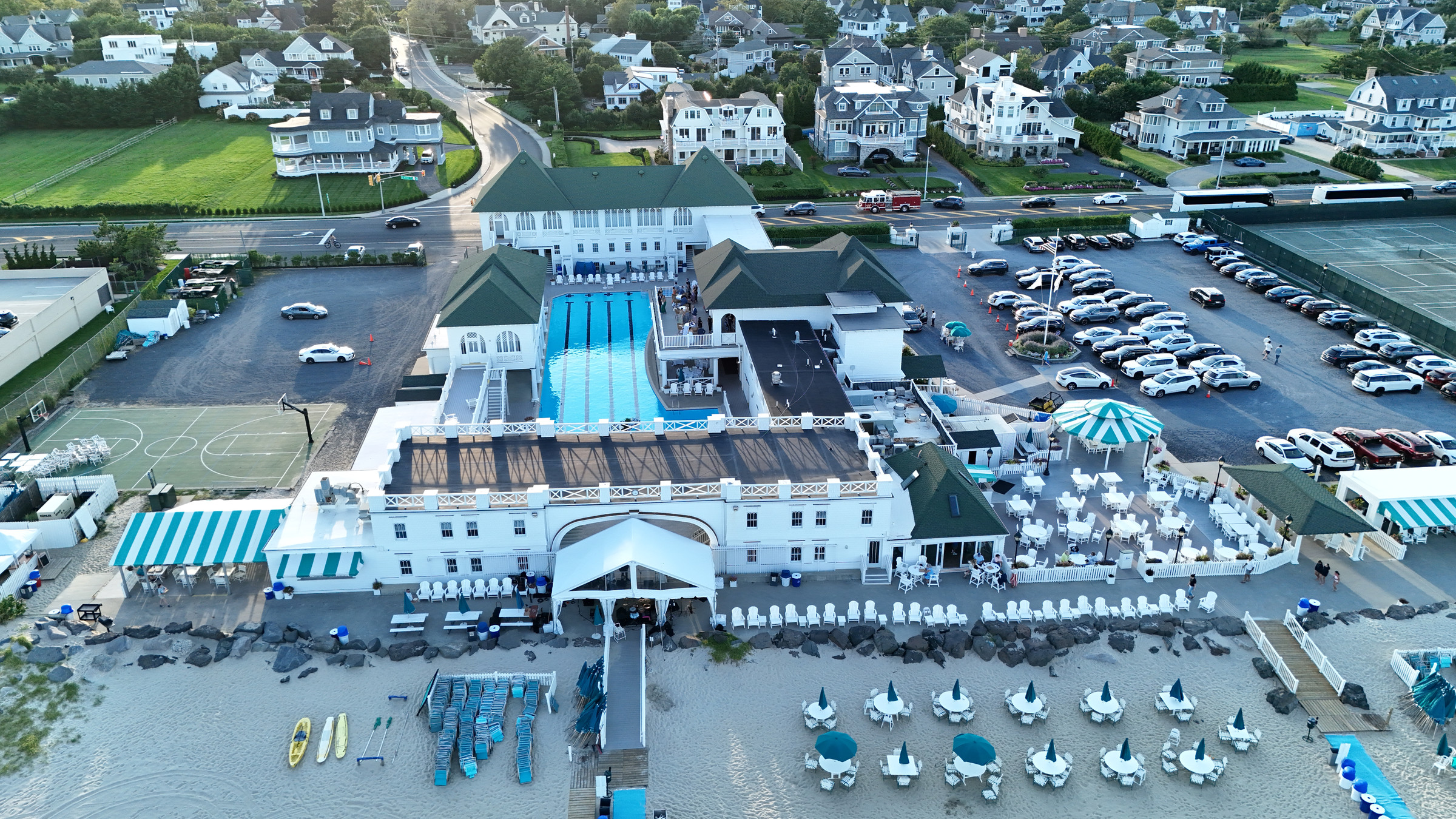
Subcontracted venue and wedding-day aerial coverage built around your timeline, creative direction, and final edit.
Travel is clear before you book.Standard rates include travel within 20 miles of Newtown, PA. If the location is farther away, any additional travel cost is included in your quote before you commit.
Visual documentation, not a professional inspection.

Roof and chimney services provide aerial images of readily visible exterior conditions. They do not diagnose damage or replace evaluation by a qualified contractor, engineer, insurance professional, or code official.

PA & NJ aerial photography + videography

See your story
from above.

Professional aerial photos, video, and visual documentation for real estate, wedding photo and video teams, contractors, and project crews across Pennsylvania and New Jersey.

Travel: Standard rates include locations within 20 miles of Newtown, PA. Any additional travel cost is quoted before booking.

FAAPart 107 Certified
DirectOne Point of Contact
ReadyEdited Digital Delivery
PA + NJLocal Coverage

What to expect

Planned, captured
and delivered.

Each project starts with its location, intended use, required views, and delivery format. Those details guide the flight and final edit.

01

Single point of contact

Planning, flight, editing, and delivery are handled through one contact.

02

Defined shot plan

The shot list is based on how the visuals will be used, including listings, estimates, project updates, and marketing.

03

Ready-to-use files

Receive edited, organized digital files prepared for listings, customer conversations, project updates, and social media.

04

Safe, compliant flights

FAA Part 107 certified, with weather, airspace, surroundings, and site access reviewed before takeoff.

What I capture

Aerial services by project type.

Photography, video, and visual documentation planned around the property, celebration, site, and intended use.

OwEmG aerial view of homes, properties, and the surrounding neighborhood
01

Real Estate

Cinematic exterior video and crisp aerial photography that reveal the home, property, and surrounding neighborhood at a glance.

Ask about this service
02

Aerial Support for Wedding Crews

Subcontracted aerial coverage for wedding photographers and videographers who want a licensed local drone pilot on the team. I follow your timeline and shot list, coordinate around the venue, and deliver organized aerial photos and clips directly to you for the final edit.

Discuss a wedding crew partnership
OwEmG aerial overview of a residential roofOwEmG close aerial view documenting damaged roof shingles
03

Aerial Roof Documentation

Detailed aerial imagery for roofers, chimney companies, contractors, and property teams, captured safely without unnecessary ladder time or roof access.

Ask about this service
06

Construction Progress

Consistent aerial documentation that makes it easy to show progress, communicate with stakeholders, and build a visual project record.

Ask about this service
Aerial view of an outdoor wedding venue and celebrationVenue · Grounds · Establishing views

Aerial subcontractor support

Extend your crew
into the air.

I work as an aerial extension of your wedding photo or video team. You retain the client relationship, set the creative direction, and control the final edit.

01Coverage planned around your timeline and shot list
02Organized photos and clean 4K clips delivered to your team
03FAA Part 107 pilot with job-specific liability coverage
04No direct marketing to your couple without permission

Flights depend on weather, airspace, venue approval, and safe operating conditions. I do not fly directly over guests.

Discuss a crew partnership
OwEmG overhead aerial view showing homes, lots, and the surrounding neighborhoodOwEmG aerial view showing homes beside a large greenbelt and wooded areaOwEmG angled aerial view showing residential homes and their surrounding neighborhood

Property · Lot · Neighborhood · Surroundings

Built for real estate professionals

Show the property
and its surroundings.

Aerial photography and video show the home, full lot, neighborhood, and nearby surroundings in views that ground-level photography cannot provide.

Edited files are delivered for use in listings, social media, property marketing, and future outreach.

01High-resolution aerial photos
02Cinematic exterior video
03Social-ready edited content
04Property and neighborhood context
Request a real estate shoot
Enhanced OwEmG aerial property map with a landmark callout and illustrative lot guidesEnhanced aerial property context

A better alternative to a generic map

Turn the aerial view into a listing tool.

Custom overlays can make a current aerial image easier for buyers to understand at a glance. Highlight the property's setting, label nearby streets and landmarks, show access points, and add optional visual lot guides directly to the image.

  • Street and neighborhood labels
  • Nearby landmark callouts
  • Property access and location context
  • Optional illustrative lot guides

Roof documentation

Overview and detail.

Overviews establish the full roof layout. Detail views provide a clear reference for visible conditions.

Overhead aerial view of a residential roof
Roof overviewCapture layout, penetrations, slopes, and accessible areas.
Close aerial view of visibly damaged roof shingles
Visible detailGive contractors and property owners a clear point of reference.

Built for roofers, chimney companies & solar professionals

Exterior documentation
without initial roof access.

Get a clear, comprehensive look at roofs, chimneys, and surrounding site conditions from the ground. OwEmG Aerials captures sharp, organized imagery that helps your team review visible conditions, communicate with customers, and plan the next step.

Request roof documentation

Aerial documentation

  • 01 High-resolution roof photos
  • 02 Multiple angles and elevations
  • 03 Wide site and access views
  • 04 Organized digital delivery

Ideal for estimates, planning, customer communication, and project records.

The business case

Why is this service
valuable to you?

Aerial imagery can reduce unnecessary site access, support customer communication, and document a property or project clearly.

01

For roofing & chimney teams

Keep your crew on the ground.

Review visible roof and chimney conditions, document problem areas, and gather useful estimating photos without sending someone up a ladder for the initial look. That means less setup, less risk, and faster conversations with the homeowner.

02

For solar professionals

Qualify the site before the climb.

See roof layout, obstructions, shading concerns, access points, and surrounding conditions before committing field time. Aerial imagery helps your team plan more efficiently and explain the proposed installation clearly to the customer.

03

For real estate professionals

Show location and property context.

Show buyers the full property, lot, neighborhood, nearby amenities, and setting in a way ground-level photos cannot. Strong aerial content helps a listing stand out online, creates better social media material, and gives buyers useful context before a showing.

Meet the fleet

Skyrover X1.
Aircraft capabilities.

The equipment matters because of what it can do for your property, project, or listing.

For contractors, the X1 captures sharp 48 MP images that can be enlarged to review visible roof, chimney, and site details without making the initial look another ladder job. Its 360° obstacle sensing adds another layer of awareness when operating around buildings, trees, and other job-site obstacles.

For real estate professionals, smooth 4K/60 HDR video creates polished property reveals, while the compact airframe lets me work efficiently and with less disruption around a home. The result is clear documentation, stronger marketing content, and useful aerial context delivered ready to share.

Plan your aerial shoot
Aircraft 01SKYROVER X1Compact aerial imaging platform
48 MPSee more roof detail
4K / 60Smooth, polished marketing video
360°Added awareness around obstacles
<249 gEfficient, low-disruption setup
40.0583° N   74.4057° W
ALT
400FT
Mike Golod · FAA Part 107 Pilot

Meet the pilot

Hi, I'm Mike.

I've had a passion for flight from a young age, and it never went away. In 2021, my wife bought me a drone, giving that lifelong passion a new direction.

That gift led to OwEmG Aerials, a local business focused on safe flying, careful composition, and useful aerial coverage for properties and projects.

Behind the name

OwEmG is named for Owen and Emma—two names that mean everything to me and keep a personal connection at the heart of every flight.

Simple from start to finish

Your shoot, in three steps.

01

Tell me about the shoot

Share the location, goal, and ideal timing.

02

I plan the flight

I confirm airspace, weather, and the strongest shots.

03

Ready-to-use delivery

Receive polished photos and social-ready video.

Clear packages, no guesswork

Choose what fits
your project.

Start with the package that looks closest to what you need. I'll confirm the scope, availability, and exact price with you before anything is booked.

Portfolio-building introductory rates
Professional work. Lower opening prices.

I'm building the OwEmG Aerials local portfolio, so the rates below are intentionally priced to make it easier to try the service. There is no ongoing commitment.

Ask about your project ↗
01

Wedding crew aerial support

Partner pricing for photographers and videographers who need a Part 107 pilot for the aerial portion of the job. You keep the client relationship and creative direction. I provide the flight coverage and hand the files back to your team.

Wedding crew partner

Venue Capture

Partner rate$225per assignment
  • Up to 60 minutes of aerial coverage
  • Venue, grounds, and establishing views
  • High-resolution photos and clean 4K clips
  • Organized delivery directly to your team
Discuss partner coverage
Extended coverage

Wedding crew partner

Coordinated Coverage

Partner rate$350per assignment
  • Up to 2 hours of coordinated aerial coverage
  • Coverage planned around your timeline and shot list
  • Venue, grounds, arrivals, and safe couple views
  • Organized photo and video handoff for your edit
Reserve aerial support
Built for ongoing partnershipsYour client remains your client.

I do not market directly to your couple without permission. Additional coverage is $125 per hour, and recurring partner pricing is available for regular volume.

Ask about recurring rates ↗

Wedding coverage requires venue approval and is limited to legal, safe flight paths. Flights are not conducted directly over guests and remain weather and airspace dependent. Travel beyond the standard service area and custom delivery requirements may affect the final quote.

02

Real estate aerial packages

Edited, ready-to-use aerial media for listings, social posts, and property marketing.

Real estate

Aerial Photos

Opening rate$99regularly $149
  • 8 to 12 edited aerial photos
  • Property, lot, and neighborhood views
  • MLS and social-ready delivery
  • Typical 24 to 48-hour turnaround
Request this package

Real estate

Aerial Video

Opening rate$149regularly $199
  • Up to 60 seconds of edited 4K video
  • Smooth exterior and neighborhood views
  • Social-ready vertical or horizontal format
  • Typical 24 to 48-hour turnaround
Request this package
Best value

Real estate

Photos + Video

Opening rate$179regularly $249
  • 8 to 12 edited aerial photos
  • Up to 60 seconds of edited 4K video
  • Property, lot, and neighborhood context
  • Ready for listings and social media
Request this package
Every real estate package includesProfessional editingOnline digital deliveryMarketing usage includedTravel within the 20-mile service area
Only need a few aerials?Up to 5 edited photos · $79 opening rate

A smaller option for a standard residential property within the service area.

Ask about the essentials option ↗

Opening rates apply to qualifying standard residential properties within the 20-mile service area. Final pricing may vary with property size, requested deliverables, travel, airspace, and turnaround.

03

Property documentation

Clear aerial imagery for an initial visual look, project planning, estimates, and customer communication.

Roofing & chimneys

Visual Documentation

Opening rate$99regularly $129
  • High-resolution overview and detail photos
  • Multiple accessible angles and elevations
  • Organized digital delivery
  • Useful for estimates and customer review
Request this service

Solar & construction

Site Progress

Opening rate$129regularly $169
  • Consistent overview and detail angles
  • High-resolution progress photos
  • Clear stakeholder-ready delivery
  • Four-visit opening plan available for $449
Plan site coverage

Roof and chimney service provides visual documentation only, not a professional inspection or diagnosis. All flights depend on weather, site access, surrounding hazards, and legal airspace.

Every project is custom quoted.You will receive an exact price before booking.
Need a smaller or different package?Tell me what you need and I'll build the quote around it.
Start a conversation ↗

Weddings, commercial properties, events & custom projects

Custom quote
Share the location and deliverables. Pricing will be based on the requested work.Get a quote ↗

Opening rates apply to qualifying standard projects within the 20-mile service area and may change as the introductory offer ends. Final pricing may vary based on property size, site complexity, requested deliverables, travel, airspace, and turnaround. Wedding coverage requires venue approval and is limited to legal, safe flight paths; flights are not conducted directly over guests. Couples and venues may also inquire directly for custom coverage. All flights are weather, property-access, and legal-airspace dependent. Roof and chimney service provides visual documentation only, not a professional inspection or diagnosis.

Local coverage

Serving a 20-mile radius
around Newtown, Pennsylvania.

OwEmG Aerials serves homes, businesses, wedding crews, roofers, chimney companies, solar teams, and project sites within roughly 20 miles of Newtown, including nearby areas of Pennsylvania and Central New Jersey.

Standard rates include travel within the circle. For locations outside it, any travel charge will be stated in the quote before booking.

Road-free state map showing a 20-mile service radius centered on Newtown, Pennsylvania
20MILE
RADIUS
Standard service area
Fixed 20-mile view
NewtownYardleyLevittownBensalemBristolDoylestownTrentonPrinceton

Before the flight

Good questions.
Clear answers.

Every site and assignment is different. These are the details clients most often need before booking.

What happens if the weather is not safe for flying?

Safety comes first. If wind, rain, visibility, or another condition makes the flight unsafe, I will contact you and arrange the next practical time.

How quickly will I receive the files?

Most standard projects are delivered within 24 to 48 hours after the flight. Larger edits and custom projects may take longer, and I will confirm timing before you book.

How are photos and video delivered?

You will receive an organized digital delivery that is easy to download and share. Final format and orientation are planned around where you intend to use the content.

Can I use the files in listings and on social media?

Yes. Marketing usage for the agreed property or project is included. If you need broader advertising, resale, or third-party usage, mention it when requesting a quote.

What does roof or chimney visual documentation include?

It provides clear images of readily visible exterior conditions from accessible aerial angles. It is not a diagnosis, code review, engineering opinion, or substitute for evaluation by a qualified contractor.

What do you need to prepare a quote?

Send the exact address, what you need to show, the deliverables you want, and your ideal timing. Photos of the site or a sample style can also help.

What if my project is outside the standard service area?

Projects beyond the 20-mile service area may still be available. Send the location and I will include any travel consideration in the quote.

Can every property be flown?

Not always. Flights depend on legal airspace, weather, site access, surrounding hazards, and any required permissions. I review those factors before confirming the shoot.

Now booking in Pennsylvania & New Jersey

Tell me what
you need to see.

Share the address, how you plan to use the visuals, the deliverables you want, and your ideal timing. I'll follow up with availability and pricing.

732-407-5097Follow on Instagram@owemgaerialsFollow on TikTok@owemg.aerials